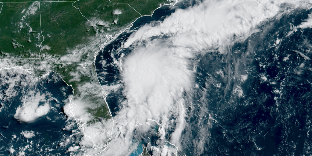
On July 5, 2025, Tropical Storm Chantal formed off the southeastern U.S. coast, becoming the third named storm of the 2025 Atlantic hurricane season. Originating as Tropical Depression Three on July 4, Chantal strengthened into a tropical storm with sustained winds of 40 mph by Saturday morning, according to the National Hurricane Center (NHC). Positioned approximately 150 miles east of Jacksonville, Florida, the storm is moving north-northwest and is expected to make landfall near Charleston, South Carolina, by Sunday morning.
Chantal is projected to bring heavy rainfall of 2-4 inches across eastern North Carolina, with isolated areas potentially seeing up to 6 inches. A tropical storm warning is in effect from South Santee River, South Carolina, to Cape Fear, North Carolina, with a watch extending to Edisto Beach. Storm surge could reach 1-3 feet, accompanied by dangerous rip currents and rough surf impacting beaches from northeastern Florida to the mid-Atlantic.
Stay updated on Chantal’s path and intensity with real-time tracking right here Cruising Earth (see links below). Monitor coastal conditions through live camera feeds at Cruising Earth’s Chantal Live Cameras. Track Live Hurricane Hunter Reconnaissance Missions into Tropical Storm Chantal.
Due to limited time over warm waters, Chantal is not expected to intensify significantly but may cause minor coastal flooding and gusty winds up to 60 mph. After landfall, it will likely weaken rapidly inland. No additional Atlantic threats are currently forecast, but vigilance is advised.
Tropical Storm Chantal Live Storm Tracking & Data
Track Tropical Storm Chantal in real-time with the latest storm data, forecasts, satellite imagery, and impact updates. Follow Chantal's projected path, wind speeds, and storm surge risks to stay informed on developments and potential effects.
Tropical Storm Chantal Live Cameras
Track and watch Tropical Storm Chantal live with real-time streaming cameras from impacted areas. Monitor storm conditions, view coastal impacts, and follow Chantal's path with up-to-the-minute footage from key locations right up to landfall.
Hurricane Hunter Live Reconnaissance Missions
Track live hurricane hunter aircraft reconnaissance missions. Track NOAA, NASA and US Air Force hurricane hunter aircraft and view real-time hurricane storm data.

Hurricane Tracker / Live Hurricane Tracking Map
Live Hurricane and Tropical Storm Tracker. Includes tracking map, live radar, forecast cones and tracks, wind speed / pressure charts, projected impacts to land and more.