City Skyline, San Francisco, California Camera

City Skyline, San Francisco, California Camera
Image Refresh In:
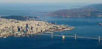
Camera view looking Northeast from Sutro Tower towards downtown San Francisco. San Francisco Bay is just beyond the city skyline.
Camera Location Date / Time:
Sat June 13, 2026 09:28 AM PDT
Additional Webcams Nearby
- Crissy Field Beach, San Francisco, California | 3.49 miles (N)
- Pier 39, San Francisco, California | 4.46 miles (NE)
- Pacifica Pier, Pacifica, California | 8.83 miles (S)
- Sharp Park Beach, Pacifica, California | 8.84 miles (S)
- San Francisco Bay / Alcatraz, San Francisco, California | 14.13 miles (NE)
View Port of San Francisco, California Ship Traffic Live Now!
The button above will take you to view live ship traffic in the Port of San Francisco, California.
San Francisco, California Current Weather Conditions
City Skyline, San Francisco, California Camera Location
Zoom In/Out On The Map Above To View Camera Location In Relation To The Port
Webcam To Port of San Francisco, California: = 4.7 miles NorthEast
Webcam Images Update Automatically
Some port webcams are live-streaming. Those that aren't live-streaming webcams display static images which are updated between once every 30 seconds to once every fifteen minutes. To make sure you don't miss any updates from the static image webcams we automatically look for a new image every 30 seconds. This will ensure you always have the latest image without having to manually reload/refresh any page.
Webcam Images May Not Always Be Available
If an image appears old, incomplete, black, or missing, it's almost always due to an issue at the webcam source, which is beyond our control. The image will return automatically once the webcam is back online. If you see a completely black image for an extended time and the ship is an area where it is daytime, feel free to report it below. Your report helps us stay on top of problem webcams.
Thank you for helping us keep the webcams working properly!