-
Register Now for a Free Account!Unlock additional site access with your free account today, takes less than a minute, and guaranteed no spam - ever. Register Now!
Ship Tracking
A brief overview on the basics of ship tracking, including the limitations of when a ship can be tracked online.
Ship Tracking 101
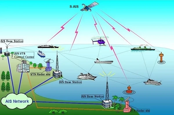
Online vessel tracking relies on the use of Automatic Identification System (AIS) data. The International Maritime Organization (IMO) requires nearly all ships greater than 300 tons to carry and use Automatic Identification Systems (AIS). Most modern vessels use a combination of satellite AIS relays and VHF, line-of-sight equipment, to transmit and receive AIS data. The VHF line-of-sight limitation requires even the tallest of vessels to be within 80-100 miles of shore in order for the data to be received. Ships with less height and ships with older/weaker transmitters will transmit significantly less than 80-100 miles.
The newer Satellite-based AIS (S-AIS) relay services are available but at a very high cost. You will not get S-AIS satellite tracking data free on the internet. The land-based VHF relaying is what all free online ship tracking uses. With this limitation you will not typically get many updates while ships are crossing large open bodies of water. Tracking updates will once again be received when the ship is closer to a shoreline and within AIS land-based reception range.
There are also a couple ways land-based AIS data can be relayed, which in turn can extend the range of land-based ship tracking. Land-based AIS data at times can be relayed through data buoys, oil-platforms and ship-to-ship through AIS transceivers installed on each. These relays can occur when one end of the relay is within a land-based receivers range while the other end is not. The buoy and platform AIS transceiver installations are typically found in areas of high shipping traffic to help with routing and collision avoidance.
Why is the ship I'm trying to track not updating?
There are a few reasons why the ship you are trying to track is not showing on the tracking map or has not updated its position in a long time:
- It is a government vessel or military ship. Government vessels and military ships are not required to use the AIS system. Almost all of these vessels have AIS equipment onboard and most typically use it outside of wartime conditions, especially when operating near civilian ships for safety reasons, but it is not required.
- The ship is out of land-based AIS reporting range. (see Ship Tracking 101 above)
- The ship has temporarily turned off its AIS reporting equipment. This is not unusual especially when a ship is docked in port. AIS reporting equipment is required to be on 15 minutes prior to departure and remain on until the ship is once again docked at its next destination. If the ship is at anchor the AIS system should remain on.
- The AIS reporting equipment onboard the ship requires maintenance. This is usually a temporary situation because onboard AIS equipment is a regarded as a safety device and is required to be in working order by International Maritime Laws.
Military & Government Ship Tracking Disclaimer
Cruising Earth’s ship tracking service utilizes Automatic Identification System (AIS) data, which is voluntarily broadcast by ships, including military and government vessels, primarily for navigational safety in areas with civilian maritime traffic. Military and government ships are not required to transmit AIS data and may choose to disable it at their discretion based on operational security (OPSEC) requirements. At no time does Cruising Earth disclose sensitive or strategic information about any ship, military or civilian.
Cruising Earth’s platform solely displays AIS data that ships voluntarily transmit, ensuring compliance with maritime safety protocols and transparency in public-domain information. This service is designed to support maritime awareness for enthusiasts and professionals while respecting the operational autonomy and security considerations of all vessels. By adhering strictly to publicly available data, Cruising Earth maintains a commitment to responsible and ethical ship tracking practices.
AIS Network Diagram